Colonial Map of Africa
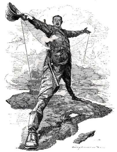
The rapid and chaotic nature of this land grab prompted concerns among European powers that their competing claims would lead to interstate conflict. To prevent this, German Chancellor Otto von Bismarck convened the Berlin Conference of 1884-1885. This pivotal, albeit deeply controversial, gathering saw fourteen European nations (and the United States, which did not participate in the partitioning) meet to formalise the rules of African colonisation. Crucially, no African representatives were present at this conference, despite their continent being the sole subject of discussion.
The Berlin Act, signed at the conference, established the principle of "effective occupation," meaning a colonial power had to demonstrate actual control over a territory, not just claim it, to legitimise its claim. This spurred a frantic dash to establish administrative outposts, military garrisons, and economic ventures across the continent. The result was the arbitrary carving up of Africa into some 40 new colonies and protectorates, with little to no regard for existing indigenous boundaries, cultures, or geographical realities.
The defining characteristic of the colonial map of Africa is its artificiality. European cartographers, often thousands of miles away, drew lines on blank or poorly detailed maps, frequently using rulers and compasses. These lines rarely respected natural geographical features or, more critically, the established socio-political structures that had governed African societies for centuries.
- Geometric Straight Lines: Many borders are remarkably straight, reflecting the simplicity of drawing lines on a map rather than complex negotiations on the ground or consideration of local populations.
- Disregard for Ethnic and Cultural Homogeneity: The arbitrary partitioning resulted in the splitting of cohesive ethnic groups across multiple colonial borders (e.g., the Maasai divided between British East Africa and German East Africa, or the Kongo people split between French, Belgian, and Portuguese colonies). Conversely, vastly different and often historically antagonistic groups were forcibly lumped together within the same colonial entity.
- Ignoring Natural Barriers and Resources: Borders often cut across rivers, mountain ranges, and fertile plains, disrupting traditional trade routes, migration patterns, and resource management systems.
By 1914, approximately 90% of Africa was under European control, with only Ethiopia (Abyssinia) and Liberia remaining independent. The colonial map's arbitrary lines have left an indelible and often problematic legacy that continues to shape contemporary Africa:
- Political Instability and Conflict: The most direct and devastating impact has been the creation of artificial states. When independence came in the mid-20th century, these newly independent nations inherited borders that enclosed a multitude of diverse and often conflicting ethnic, linguistic, and religious groups, while simultaneously dividing historically unified communities. This forced cohabitation often fueled ethnic tensions, leading to civil wars, coups, and border disputes as various groups vied for control within the inherited, often fragile, state structures. The Biafran War in Nigeria, the Rwandan genocide, and numerous conflicts in the Horn of Africa are tragic examples of this legacy.
- Economic Disruption and Exploitation: Colonial powers reoriented Africa’s economies to serve their own industrial needs. Production shifted from diversified, subsistence agriculture to monoculture cash crops (e.g., cocoa, coffee, rubber, cotton) and the extraction of raw materials (minerals, timber) destined for Europe. Infrastructure, such as railways and ports, was built primarily to convey these resources from the interior to the coast, not to foster intra-African trade or local industrial development. This created economies dependent on external markets and vulnerable to global commodity price fluctuations, a pattern that persists in many African nations today.
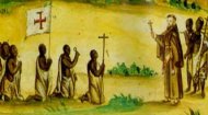
- Sociocultural Transformation: The imposition of European languages (English, French, Portuguese), education systems, legal frameworks, and administrative structures significantly disrupted traditional African societies. While offering some benefits like access to modern medicine and education, it often came at the expense of indigenous knowledge systems, languages, and governance structures. New social hierarchies emerged, often based on proximity to colonial power or the adoption of European norms, further straining inter-group relations.
The colonial map of Africa is not merely a historical curiosity but a powerful reminder of a period of profound external intervention that sculpted the continent into its current form. While African nations have made immense strides since independence, addressing the challenges born from these inherited borders – fostering national unity amidst diversity, building robust democratic institutions, and achieving equitable economic development – remains a central task. Understanding the origins and characteristics of these lines is crucial to comprehending the complex dynamics of modern Africa and its ongoing journey of self-determination and growth.
The earliest map of Africa is believed to have been created in 1389 and is called the "Da Ming Hun Yi Tu" (above) which shows the continent as part of a wider map of the Ming Dynasty. Created in silk it shows Africa more than a hundred years before the first western explorers from Portugal started to chart parts of Africa's coastline. The map appears to show Lake Victoria and the River Nile. |