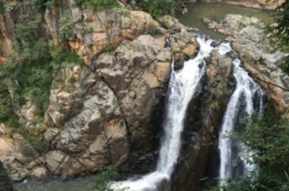
Eswatini is a small country about the size of Wales sharing a 267 mile border with South Africa to the north, south and west and a 65 mile border with Mozambique to the east. It has a sub-tropical climate with about 75% of total rainfall occurring from October to March. The country 's topography is mainly mountains and hills, with some moderately sloping plains. Its lowest point is the Great Usutu river at 69ft and its highest point is Emlembe, part of the Drakensberg mountain range at 6018ft.
Eswatini is made up of four areas representing all of the terrain if Africa except for desert. Highveld to the west has mountains, rivers, waterfalls and gorges with a generally temperate climate of warm, wet summers and dry winters when the temperature can rise sharply during the day, but with cold nights. Next to Highveld is Middleveld, slightly lower with fertile valleys and a warm climate that makes it ideal for farming and is the main crop growing area of Eswatini. As you proceed east, you enter into the sub-tropical Lowveld where sugar and citrus are cultivated for export and cattle are reared. The smallest area of Eswatini is Lubombo which shares the country's border with Mozambique. Lubombo, again, has an abundance of mountains and supports mixed farming.
Eswatini has four main rivers; the Komati and Lomati river systems originates in South Africa then bend through Swaziland before flowing back into South Africa and then into Mozambique; the Mbuluzi River originates in Swaziland and flows out into Mozambique. The Usuthu River again originates in South Africa and flows out into Mozambique whilst the Ngwavuma, in the south of the country, rises in Swaziland itself and flows into South Africa. These rivers are home to nine major dams with seven being used for irrigation purposes, one for hydroelectric purposes and just one for water supply.
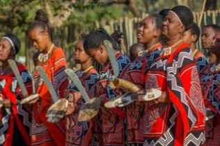
Most people visit Eswatini for the amazing images of its countryside however it has many other attractions for the tourist from the Malkerns Valley with its arts and crafts; the Ngwenya Glass Village close to the border with South Africa in the north west and the Mlilwane Game Park, Eswatini's main nature reserve. Those with an interest in history will enjoy ancient bushmen paintings at Nsangwini in the northern Hhohho region as well as others at Sandlane and Dlangeni. The video (above) provides some stunning images of Eswatini.