Size of Africa
The real size of Africa demonstrated in a map showing the actual real size of Africa compared to other continents:
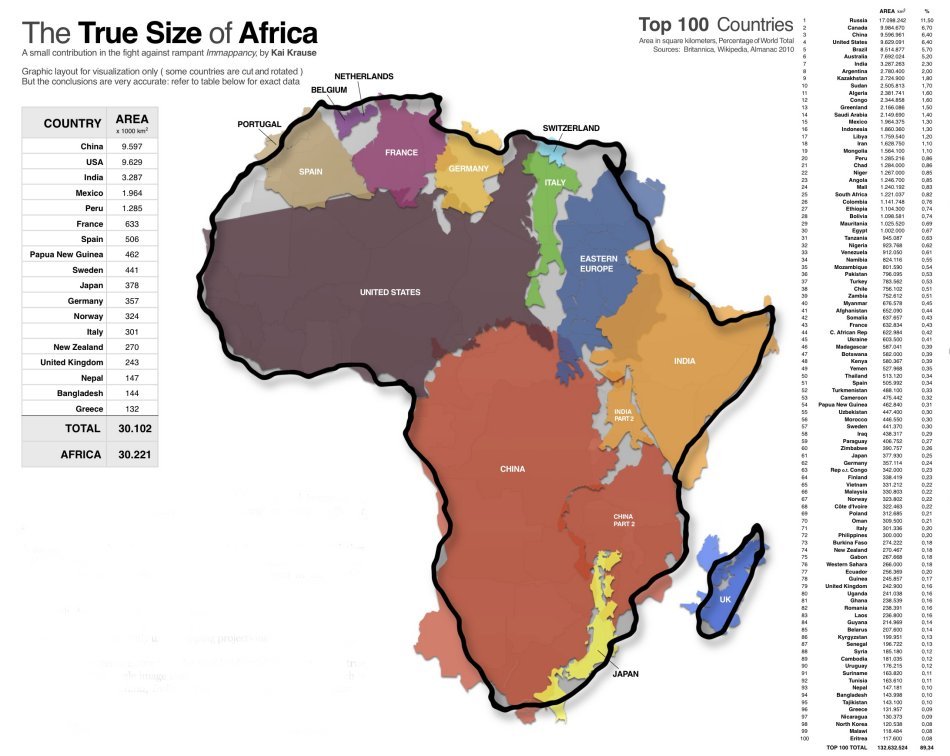
Size of Africa |
Size of Africa |
Size of Africa | Size of Africa |


This map of the true size of Africa is part of our About Africa series for volunteers. More here!
More >
|
|
For generations, our understanding of global geography has been profoundly shaped, and often distorted, by the maps we commonly encounter. Among the most pervasive of these distortions is the widely held belief that Africa is a continent of moderate size, perhaps comparable to North America or Europe. This perception, however, is a profound misconception, masking the true, staggering scale of the world's second-largest continent.The primary culprit behind this global illusion is the Mercator Projection, a cylindrical map projection devised by Gerardus Mercator in 1569. While revolutionary for its time and invaluable for maritime navigation (as it preserves angles and shapes of small objects, making compass bearings straight lines), it comes with a significant trade-off: it drastically exaggerates the size of landmasses as they get further from the Equator. Think of it like peeling an orange and trying to flatten its curved peel onto a flat surface. To achieve this, you'd have to stretch and tear parts of the peel, particularly where the curve is most pronounced. The Mercator projection does something similar with the Earth. Regions closer to the poles, such as Greenland, Canada, Russia, and Europe, are stretched horizontally, appearing far larger than their actual area. Conversely, landmasses near the Equator, like Africa, are compressed, appearing smaller than they truly are relative to their northern counterparts. So, what is the "real size" of Africa? Prepare to have your geographical worldview profoundly shifted. Africa is truly immense. To grasp its scale, consider these comparisons: You could fit the United States, China, India, Japan, and most of Western Europe (including Germany, France, Spain, Italy, the UK, and Eastern Europe) all together comfortably within Africa's landmass. This is not an exaggeration; detailed analysis and visual overlays confirm this astonishing fact. The surface area of Africa is approximately 30.37 million square kilometres (11.73 million square miles). This makes it larger than China, India, the United States, and all of Eastern Europe combined. Algeria, Africa's largest country, is roughly four times the size of France. The Democratic Republic of Congo (DRC) is larger than all of Western Europe. Even individual African nations, often perceived as small on a Mercator map, are vast. This grand scale is often obscured on traditional maps, where Greenland, for example, appears comparable in size to Africa, despite being nearly 14 times smaller in actual land area. Similarly, Canada and Russia seem to dwarf the continent, when in reality, Africa is larger than all of Russia, Canada, the United States, and China combined. Africa's gargantuan size is not merely a geographic trivia point; it underscores the unparalleled diversity of the continent. Far from being a monolithic entity, Africa is a mosaic of approximately 54 independent countries, thousands of distinct ethnic groups, and over 2,000 different languages. Its vastness translates directly into an incredible array of landscapes and climates: from the scorching Sahara Desert in the north to the lush rainforests of the Congo Basin, the expansive savannahs of East Africa, the towering peaks of Kilimanjaro and Mount Kenya, and the fertile farmlands of the Nile Delta. This geographical breadth supports a staggering biodiversity, making it home to some of the world's most iconic wildlife and unique ecosystems. Furthermore, Africa is exceptionally rich in natural resources, possessing significant reserves of diamonds, gold, oil, gas, cobalt, uranium, and vast tracts of arable land and freshwater. Its rapidly growing population, projected to reach 2.5 billion by 2050, also signifies a colossal human resource and an increasingly influential global demographic. Understanding Africa's true size is crucial because the persistent misperception has far-reaching implications:
In an increasingly interconnected world, accurate geographical literacy is more vital than ever. Challenging the distortions imprinted by old maps and recognising Africa's true, colossal dimensions is not just about correcting a cartographical error. It's about fostering a more informed, respectful, and equitable understanding of a continent that is, by every measure, a cornerstone of humanity's past, present, and future. It's time our mental maps caught up with Africa's majestic reality. |


