|
Algerian Desert |
Algerian Desert |
Algerian Desert | Algerian Desert |


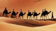
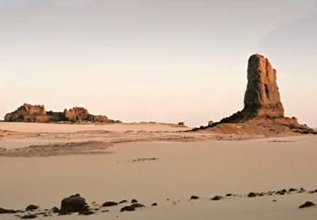
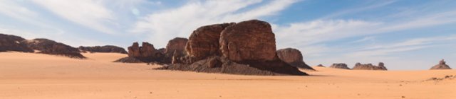
Algerian Desert LifeDespite its harsh reputation, the Algerian Desert supports a surprising array of life, each species finely tuned to its environment. Flora: Plants have developed remarkable strategies to survive. Deep root systems tap into elusive underground water sources. Succulent leaves store precious moisture, and some plants bloom rapidly after the rare rainfalls, completing their life cycle before the moisture evaporates. Iconic desert plants include the hardy date palm, crucial to oasis life, and various drought-resistant grasses and shrubs. Fauna: Many desert animals are nocturnal, emerging in the cooler hours to forage. The fennec fox, with its enormous ears for dissipating heat, is a prime example. Other inhabitants include various species of gazelles, addax, desert monitors, scorpions, and a surprising variety of birds that either migrate through or have adapted to the arid zones. Oases, fed by underground springs, serve as vital biodiversity hotspots, supporting more lush vegetation and animal life. The Algerian Desert has been home to humans for millennia, preserving an astonishing record of ancient civilisations and resilient cultures. Ancient Heritage: The Tassili n'Ajjer is an open-air museum of rock art, with tens of thousands of engravings and paintings dating back 12,000 years. These captivating artworks depict prehistoric life, changing climates, and diverse fauna – from elephants and giraffes to early pastoralists – providing invaluable insights into ancient Sahara. Nomadic Life: The desert is the traditional homeland of the Tuareg people, often referred to as the "Blue Men of the Sahara" due to their indigo veils. Their nomadic lifestyle, deep understanding of the desert, rich oral traditions, and unique culture are inextricably linked to this environment. Oases like Ghardaia, Timimoun, and El Oued have long served as vital trading posts and centres of sedentary life, their distinct architectural styles reflecting centuries of adaptation to the desert climate. Economic Significance: While tourism, though niche, is growing through adventure travel and cultural experiences, the primary economic driver of the Algerian Desert is its vast reserves of oil and natural gas. These resources have transformed once-remote areas into bustling industrial hubs, bringing modern infrastructure and challenging traditional lifestyles. The south-west of the Algerian desert is home to 165,000 Saharawis living in semi-autonomous refugee camps at Tindouf, having fled the troubles Western Sahara. Temperatures there often soar above 50 degrees and there is little or no vegetarian. Food, water and supplies are furnished by international aid agencies, however, despite this, a high proportion of children suffer from malnutrition. This video, together with our image carousel, allows you to experience the solitude and beauty as well as the harshness of the Algerian Desert. |


